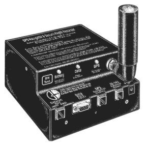
Figure 1. The Cambridge GPS Recorder
Presented at the 51st Annual Meeting of the
Institute of Navigation
Colorado Springs, CO June 7, 1995
Isn't this all a bit silly? Actually, no. The probability that your Boeing jet from Wherever to Colorado Springs will arrive on time is exceedingly high. The probability that a glider will fly to 22,000 feet over Colorado Springs is very low. It takes the right weather conditions, skill, and some luck. Pilots, in general, like to be recognized for such achievements (In this case, a Diamond Altitude Gain badge).
For altitude gain badges and records, a recording altimeter called a Barograph is used. Barograms are also required in competitions to prove that the pilot did not land and re-launch during the task. Over the past 30 years the IGC has evolved a complex set of rules for use of photographs and barograms as evidence. Elaborate procedures and precautions have been written into the rules to prevent cheating.
A solicitation to provide GPS Recorders for the NZ Competition was sent to potential vendors in July, 1993. 10 proposals were received. Cambridge won the competition by promising further trials at our expense, and inexpensive rentals to pilots at the World Competition.
A trial involving 10 recorders at a regional New Zealand competition was completed successfully in November, 1993. The New Zealand Pre-World Competition was successfully scored using 31 Recorders in January, 1994. These real-world experiences led to extensive Firmware and PC software revisions in preparation for the "Real Thing" in January, 1995.
Only a small percentage of glider pilots actually fly in competitions. A larger group of pilots worldwide participate in badge and record flying. We felt the number of pilots doing this would go up if the process were less complicated and intimidating. It is more difficult to prevent cheating in badge and record flying than in competitions. We therefore chose to design system security around the more difficult situation.
There was no compelling reason for the IGC to change the rules regarding evidence for flights to incorporate GPS data. But the market for badge and record pilots would not be open until the rules permitted GPS evidence. We felt that changing the IGC rules would be a slow and agonizing process unless a serious effort was made to ensure reliability and security of the system. We also felt that a successful demonstration at a World Championship would help to advance the rule change process.
Finally, our early flight recordings showed, for the first time, differences in technique that distinguish winning pilots from the also-rans. We felt that flight recordings could be valuable in training glider pilots for cross-country flying. We chose a short sampling interval of 4 seconds because it reveal the details of style, particularly while circling in thermal lift.
Figure 1. The Cambridge GPS Recorder
The goal of quick installation at a competition site is supported by the use of telephone style modular cables and connectors. The thin cable can easily be drawn through tight channels in the glider fuselage, and connectors can be attached with a crimp tool.
Racing gliders go to extremes to reduce drag. It is not acceptable to mount a GPS antenna on the outside surface of the fuselage. Some modern gliders use carbon fiber in the fuselage, so the antenna must be mounted under the clear plastic canopy. We chose to use GARMIN's Quad Helix antenna and to provide a variety of antenna mounting brackets.
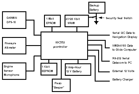
Figure 2. Simplified GPS Recorder Block Diagram
GPS position and time come via NMEA-0183 sentences from an integral GARMIN GPS-10 8- channel fast multiplexing C/A GPS engine. The basic GPS accuracy of ±100 meters is superb when compared with photography, so this application does not need accuracy enhancing techniques such as DGPS for horizontal position data.
Historically, sport aviation uses pressure altitude for badge and record flights, so the instrument also incorporates a pressure altitude sensor. GPS altitude has excellent long-term stability and poor short time stability while pressure altitude has good short term stability but is subject to variations in barometric pressure and to sensor drift with time and temperature. The two measurements are therefore complementary. The pressure sensor is not used to provide baro-aiding to the GPS.
Modern Gliders often have auxiliary engines. Running the engine during a competition or badge flight is in very bad taste. Barographs have been equipped with a variety of devices for detection of engine run. We wanted a system with no physical connection to the engine. The GPS Recorder has an internal, calibrated microphone and amplifier tuned to the frequency spectrum of the engine and propeller blades. Average noise level in the glider is continuously recorded for post flight analysis.
Gliders often climb by circling in thermals. This mode of flight is characterized by very tight circles, high bank angles, and violently ill passengers. Sustained turn rates of >20° /sec with bank angles of >45° are common. We were concerned about the performance of the GPS receiver and antenna under these conditions. We chose to record both horizontal and vertical Estimated Position Error (EPE). This data has been helpful in optimizing antenna location. The GARMIN GPS-10 has proven agile in changing satellite constellations as required without losing fixes.
The maximum rate at which data is stored is one sample every 4 seconds. At this rate 12 hours of flight can be recorded. The information recorded includes the following: Date, Time, Horizontal Position, Horizontal EPE, GPS Altitude, Vertical EPE, Pressure Altitude, Ambient Noise Level, and a Status byte.
At the end of the competition flying day, GPS recorders are brought to the competition office for scoring. This is a hectic activity manned by volunteers. Unless appropriate precautions are taken there is a very high probability that a flight file will be lost or assigned to the wrong pilot. The GPS Recorder design anticipates this class of human error. The pilot's name and other relevant data is transferred to the GPS Recorder from the scoring computer. Each pilot sees his name displayed on the navigation screen when power is turned on. This helps prevent pilots from flying with the wrong GPS recorder.
The GPS Recorder knows UTC and Longitude. It computes local midnight. After a day's flights, all flight data that began on a given calendar day is transferred to a PC file. PC file naming is completely automatic. The file name is based on recorder serial number, calendar day, month, and year. Flight files are never erased in the GPS Recorder. This means that if the PC fails during flight evaluation activity, data may be extracted from the GPS Recorders the following day. It also means pilots can make flight files for their own use.
At a fix interval of 4 seconds, a typical competition flight requires 4000 to 6000 fixes. Data is transferred from the recorder to the PC via a serial data cable attached to the PC COM 1-4 port in a proprietary, compressed format. At 9600 baud, transfer would take up to 5 minutes per flight.
We felt this would be unacceptable at a competition, so a 57 kbaud block transfer protocol was developed. This reduced transfer times to less than one minute per flight.
Once flight data is in a PC, it is theoretically capable of being altered by a clever programmer. This is an unacceptable situation for badge and record attempts where an official observer may not be present to prevent cheating. To simplify flight validation at a remote site, the GPS recorder "signs" the complete flight file with an encrypted message as it is transferred to the PC. The PC program checks the flight file and also creates a "signature". If flight data is modified, the PC signature will not match that generated by the GPS recorder. This allows alteration of PC flight files to be detected by IGC an FAI officials.
Pilot and glider information is kept in a separate PC database. This includes pilot preferences for units of measure such as Statute or Nautical miles. It also includes the racing class of the pilot's glider.
A complete suite of graphics programs displays overall, or detailed zoom views of the flight in plan and elevation views. A typical detail view is shown in Figure 3.

Figure 3. Copy of PC Screen showing Glider Navigation around a Turnpoint
Detailed information about each position "fix", including graphical representation of fix accuracy can be shown. In this case the flight path is from the middle left side around the turnpoint. The detail information is for the last displayed point at the lower left. The radius of each fix circle is the EPE for that fix. At present, contest volunteers record start and finish times to the nearest second, and check that turnpoints have been properly achieved. This typically takes about 1 minute. Sufficient data exist in the flight recordings and PC databases to completely automate this process.
A recently developed program displays multiple flights on the screen. This is very helpful in analysis of competition strategy. We expect it will also be useful in glider pilot training at all levels. Another program prints scaled flight traces. This permits transparencies to be placed over topographic maps to aid visualization of those sources of rising air which enables gliding flight. In future we expect to provide topographic map information graphically on the PC screen.
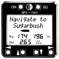
Figure 4. The Navigation Display & Controls
We studied low cost GPS receivers available in 1992 and attempted to understand the strengths and weaknesses in each user interface. We decided that it was easier to select Navigation Points by scrolling through a list of non- abbreviated names than to enter a number or an identifier code. This led to 12 character Navigation Point names and the use of a mouse-like control structure.
Navigation functions are controlled by 5 keys using on-screen labeling. LEFT and RIGHT arrow keys move among 28 different types of screens. The UP and DOWN keys modify information shown in each of the screens. GO key function is context dependent. An important design element is that repeated pushes of the GO key always returns to the Primary Navigation screen. This is a great comfort to the new user. In Navigation Point selection screens, the GO key selects the new Navigation Point as well as returning to the Primary screen. For Turnpoint and Task editing functions, the GO key branches to a second set of data entry screens.
Simple TN Liquid Crystal Displays (LCD) are faster than Super Twist displays used in laptop PC's. With our custom TN display, we found it was easy to scan up to 4 names/second. A limit of 250 Navigation Points per contest site means it is possible to scroll through all possible points in one minute. Typical contests have only 50 turnpoints, reducing average scroll times to 5 seconds. Landable points are on a different screen list than competition Turnpoints, further reducing average scroll time.
The GPS Recorder computes Distance and Bearing to all available Navigation Points as a background task. Information for the nearest 10 Navigation Points is updated on a faster schedule. This data is sent to the display on a regular schedule consistent with other functions of the recorder. The display is responsible for organizing this data in lists according to Navigation Point attributes. For example, Landable Points are listed in order of distance from the current position. The display µcontroller is dedicated to the screen and keys; this enables very fast key response.
2-seat gliders are arranged with front and rear cockpits. Another benefit of a local µcontroller is that 2 display screens can be used with one GPS Recorder. Each pilot is free to use the display without fear of changing information presented to the other pilot. The single exception to this rule is selection of a new active Navigation Point.
It is impossible for a pilot to learn 28 screens in 5 minutes, so screens were carefully arranged in order of usefulness during flight. Only 3-5 screens are needed for basic operation. Non-cryptic labeling and consistent control actions make it easy to teach basic navigation functions to a pilot with limited English language skills.
As a result of this success, the decision was made to score the next World Gliding Championships, in St. Auban, France with GPS. The atmospheric conditions at this site are not as spectacular as those in New Zealand. This means that photo evaluation could be used. However, it was felt by the organizers of this future competition that GPS evaluation is a radical improvement over the earlier photo based system.
At the same meeting, a standard for GPS Recording data files was approved. This standard was developed over the last two years by a group of gliding instrument manufacturers and independent software consultants. The data standard permits flight recording PC files made with one vendor's equipment to be evaluated on another vendor's PC program.
Trials began in early 1992 and continued for 2 years before the World Gliding Championships in January, 1995. The GPS-based system was a complete success at this competition with no film development being required for flight evaluation.
The FAI and IGC have approved new rules using GPS evidence for validation of badge an record glider flights. It is expected that GPS Flight recording will spread quickly to other branches of sport aviation.
Development of a Secure, GPS-Based Flight Recorder for Sport Aviation on soaring.guenther-eichhorn.com